
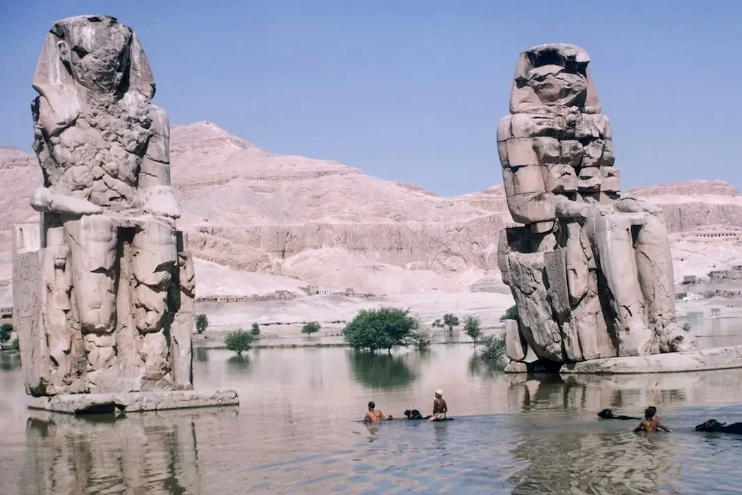
Every year for roughly 11,500 years, the Nile rose about 38 feet above its dry-season level at Luxor, swallowed the floodplain whole, and then withdrew, leaving behind the silt that fed one of the longest-running civilizations in history. Without that cycle, there is no Karnak, no Valley of the Kings, no New Kingdom empire — just desert. This is how that water worked, what it built, and what happened the year it finally stopped.
How the Flood Worked
The flood had nothing to do with rain falling on Egypt itself. It began thousands of miles south, in the Ethiopian Highlands, where the Intertropical Convergence Zone brings heavy monsoon rains between May and August. That water poured into the Blue Nile and the Atbara River, sending a surge north through Sudan and into Egypt’s narrow valley. By June the river at Luxor had started to rise; by September it was a vast inland sea; by October it typically reached its peak. Flood levels were also predictable by location — historically around 45 feet at Aswan, 38 feet at Luxor and ancient Thebes, and 25 feet at Cairo, decreasing as the river spread and slowed downstream.
The Egyptian Year in Three Acts
Ancient Egyptians didn’t just endure the flood — they built their calendar around it, timed against the first pre-dawn appearance of the star Sirius each year:
- Akhet (Inundation), from June: The river overflows its banks and covers the floodplain. Farming stops entirely; the flood controls the calendar.
- Peret (Emergence), October to February: As the water recedes, it leaves fresh silt behind. Farmers plant directly into it, with little need for added fertilizer.
- Shemu (Harvest), March to May: The dry season, when crops are gathered and stored or traded, generating the agricultural surplus that funded everything else.
What 11,500 Years of Sediment Reveal
In 2024, researchers from the University of Southampton published a study in Nature Geoscience that rewrote part of this story. The team drilled 81 boreholes across the Nile Valley near Luxor and dated the layers using Optically Stimulated Luminescence, reconstructing 11,500 years of river history. From roughly 11,500 to 4,000 years ago, the Nile was cutting downward, carving a narrower floodplain — the era spanning early hunter-gatherer settlement through the pyramid-building Old Kingdom. Around 4,000 years ago, that pattern reversed: the river began depositing sediment instead, and the floodplain expanded dramatically, improving soil fertility across the Middle and New Kingdom periods. That shift lines up closely with the era of Egypt’s greatest monumental building, including the expansion of Karnak.
How the Flood Built Luxor
Look at Luxor’s temples and you’re not just looking at masonry — you’re looking at stored hydraulic energy. Every surplus harvest the flood produced eventually became a chisel stroke somewhere on the West or East Bank.
Temple placement followed the water with real precision. Karnak and Luxor Temple sit on elevated ground near the river — close enough to the flood zone to claim a visible link to the inundation, high enough to stay dry through it. Across the river, the royal cult temples were oriented toward an ancient, now-vanished Nile channel that once ran along the West Bank, so funeral processions could travel by boat directly to the edge of the necropolis.
One temple breaks that pattern in an interesting way. Amenhotep III’s mortuary temple at Kom el-Hettan is the only royal cult temple in Thebes built out on the floodplain itself, and geoarchaeological research has shown that regular flooding there didn’t actually begin until after the temple had already gone out of use — a useful reminder that even a subject this well-documented still holds corrections to the popular version. See the full Kom el-Hettan story for how that site’s ruin is really explained.
Basin Irrigation: Turning Flood into Farmland
None of this worked by accident. Egyptian farmers divided their fields with earthen dams and levees into basins that could be flooded in a controlled way. When the inundation came, the basins were allowed to fill; after about 45 days — long enough for silt to settle and the ground to soak through — the water was drained back to the river. The result was farmland that produced wheat, barley, flax, and papyrus year after year without exhausting the soil, entirely without artificial fertilizer.
Hapy, Osiris, and the Politics of the Flood
For ancient Egyptians, the flood wasn’t a weather event; it was a god. Hapy, depicted with blue skin, embodied the inundation’s life-giving power, and the flood itself was folded into the Osiris myth — read as Isis’s tears for her murdered husband, with the crops that followed standing in for his resurrection. Controlling the story of the flood meant controlling a claim to legitimacy, which is why Hapy appears at the Temple of Luxor in the sema-tawy motif: two Hapy figures binding papyrus and lotus together, representing the union of Upper and Lower Egypt through the water itself.
The Nilometer: Egypt’s Earliest Warning System
To track the flood’s danger and promise, Egyptians built nilometers — stepped shafts and marked columns at the river’s edge that measured water levels with real precision. Readings taken at Aswan, where the flood arrived first, were relayed north, giving cities like Luxor several days’ notice of what was coming. A flood within the expected range meant a good harvest and a season of celebration; a flood that fell short brought rationing and political anxiety; a flood that ran too high could destroy mudbrick villages, drown livestock, and contaminate wells.
When the Sky Failed the River
The flood’s biggest threat sometimes came from nowhere near Egypt. Historical records tie some of the worst Nile flood failures to distant volcanic eruptions, which injected aerosols into the atmosphere and suppressed the monsoon rains feeding the Blue Nile. A civilization capable of building Karnak could still be destabilized by a mountain erupting on another continent entirely.
1970: The Year the Flooding Stopped
After roughly 11,500 years, the cycle ended. The completion of the Aswan High Dam in 1970 gave Egypt year-round irrigation and reliable electricity — and permanently stopped the annual flood. The effects are still unfolding: without yearly silt, farmers now rely on chemical fertilizer; the Nile Delta is eroding into the Mediterranean; and shifting groundwater near some archaeological sites, no longer replenished by regular flooding, is creating new preservation problems. Wafaa El-Nil, the “Fidelity of the Nile” festival once tied to the flood’s arrival, is still marked every year on August 15 — now a commemoration of water that no longer comes rather than a celebration of water that has.
Where You Can Still See the Flood’s Traces
The Nilometer at Elephantine Island, Aswan: One of Egypt’s oldest surviving nilometers — a stone stairway cut into the riverbank, with markings once used to measure and record flood height. It sits within the Aswan Museum grounds and is reached by a short boat crossing from the Aswan corniche; check current hours and admission before visiting, as with any Egyptian antiquities site.
Wafaa El-Nil, August 15: If you’re in Egypt in mid-August, this is the closest thing left to experiencing the old flood calendar — a two-week commemorative festival, now symbolic rather than tied to an actual rising river.
Best time to visit generally: Since the dam removed the seasonal flood, there’s no flood season to plan a trip around — Luxor and Aswan are both most comfortable October through April, avoiding peak summer heat. See the best times to visit Luxor.